GIS in practice: Using spatial data to add value
Geographic Information Systems (GIS) is a powerful tool that provides the ability to gather, manage and analyse spatial data. Below are some examples of how our GIS team has used data in a spatial form to add value and clarity to our projects.
Culturally and Linguistically Diverse workforce gaps in agriculture
We conducted research for Agriculture Victoria to identify where Culturally and Linguistically Diverse (CALD) communities are co-located with agriculture industries and understand the workforce gaps facing these communities. To locate these regions we analysed and mapped ABS Census data to determine where key agricultural regions overlapped with areas of high CALD community settlement. We were also able to analyse how this has changed over time.
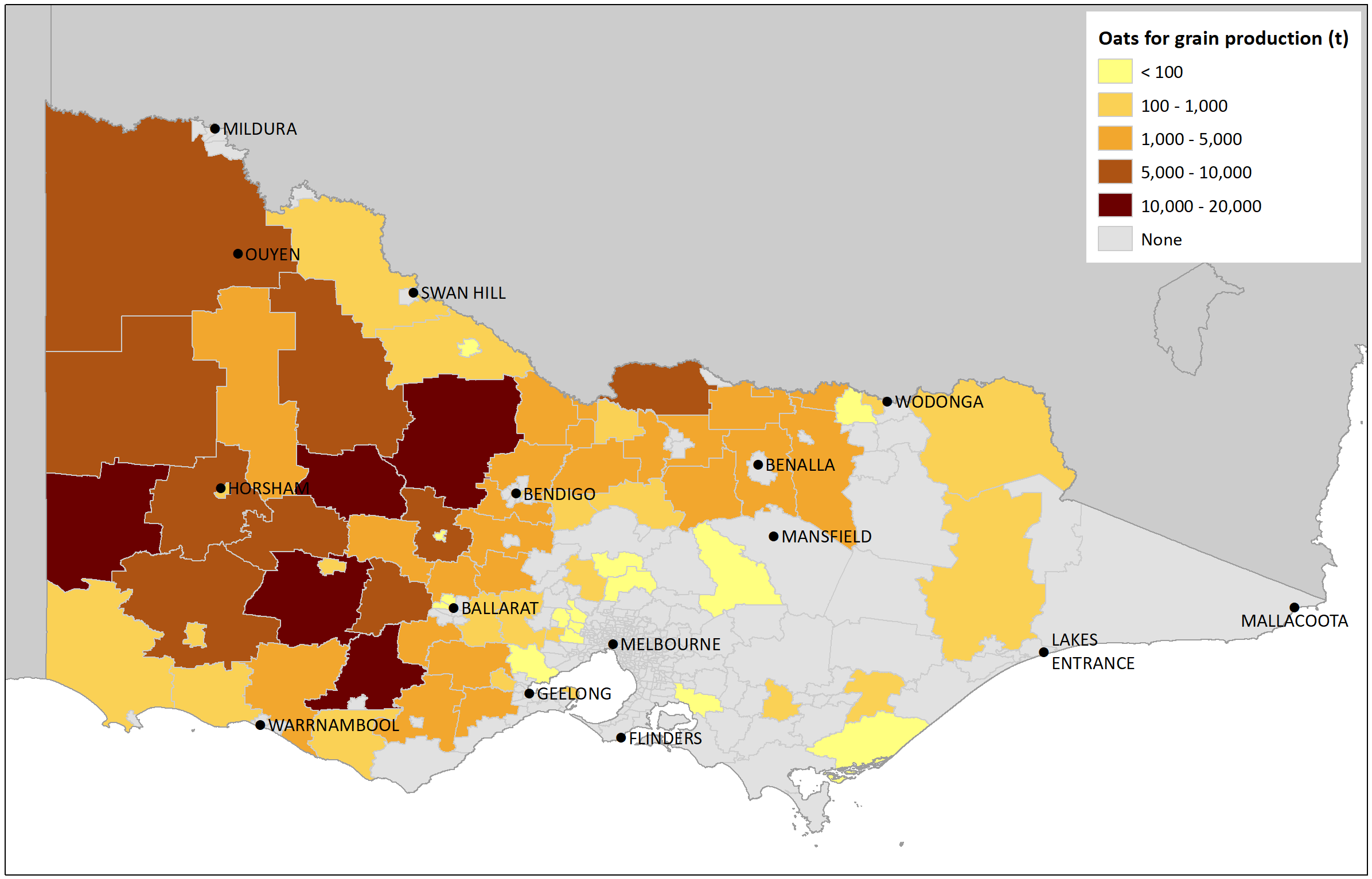
An example of a GIS map of oat production in Victoria, which was compiled using data from the ABS Agricultural Census 2015-16.
Yarra Ranges Domestic Wastewater Management Plan
We conducted a spatial risk assessment for Yarra Ranges Shire Council to locate areas where the risk of domestic wastewater impacts on the environment, public health and amenity were highest. We utilised spatial data sets that showed the key risk factors and combined the datasets to determine an overall risk value.
Barwon rivers discussion paper
We worked with the Victorian Department of Environment, Land, Water and Planning (DELWP) and the Barwon Ministerial Advisory Committee (MAC) to produce a discussion paper, Our living rivers of the Barwon, that aimed to capture the community vision for the rivers of the Barwon and identify opportunities to shape the way the catchment is managed into the future. We produced the maps that feature in the paper, which provide visual and location context. See the Barwon River Action Plan for more information.
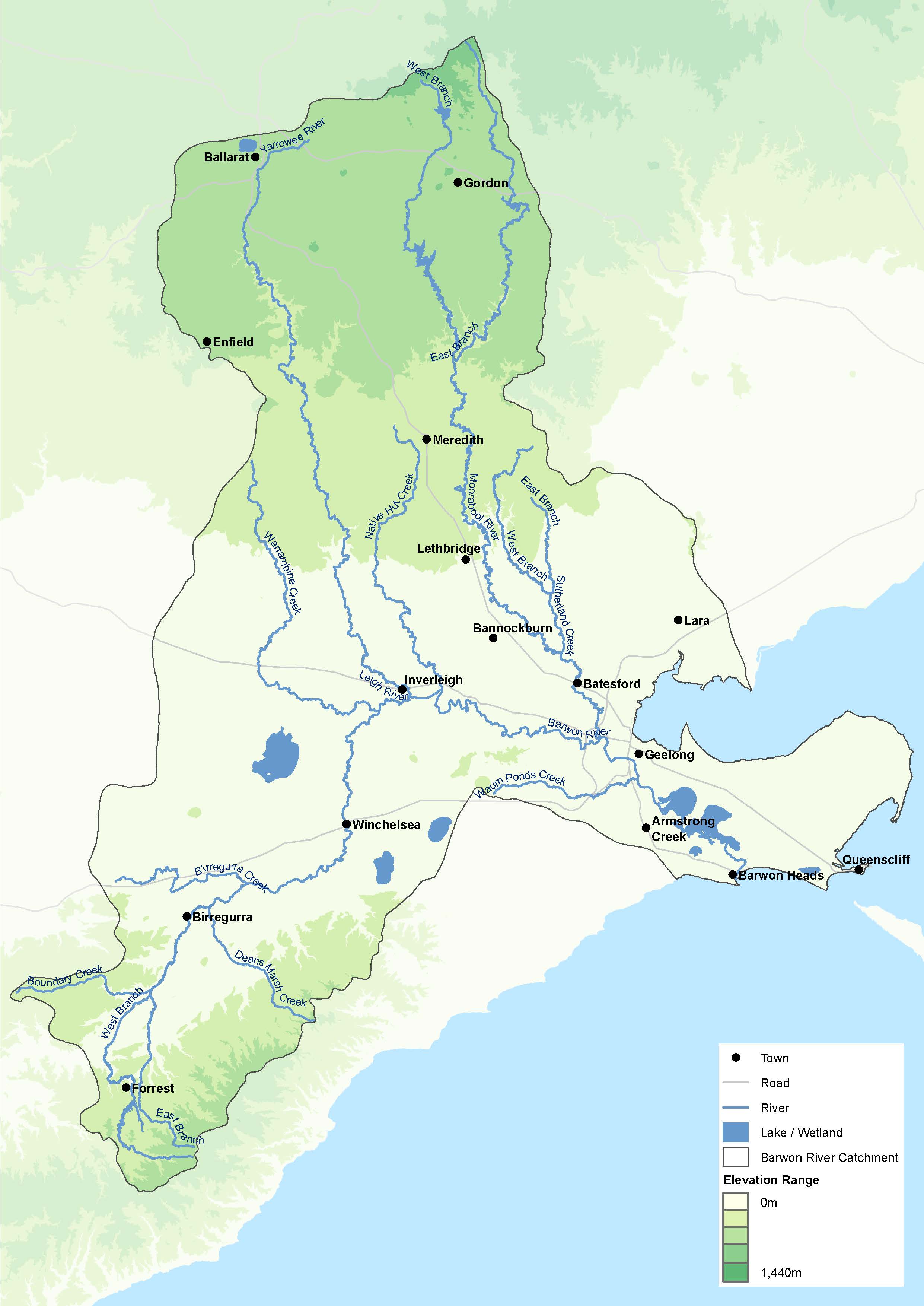
A GIS map of the Barwon Basin produced by RMCG.
Corangamite Catchment Management Authority sustainable agriculture future directions paper
RMCG undertook a spatial assessment to identify the main agricultural land uses in the Corangamite Catchment Management Authority (CCMA) region and determine how they intersected with the priority natural assets in the region, including habitat, waterways and revegetation priority.
The purpose of this spatial prioritisation was to identify and justify where in the landscape the CCMA should work with private land managers on sustainable agriculture activities. It aimed to highlight areas where potential high-risk agricultural land uses and practices coincided with high value natural assets.
Shepparton East agricultural land use options
RMCG produced a series of maps that formed part of an analysis into agricultural land use options in Shepparton East. The maps offered further context to the research by helping to visualise data, which provided a better understanding of what was happening in the region. Maps showed elements such as land use, planning zones and overlays, lot size and property ownership size, soil and agricultural land suitability. The maps and spatial analysis helped understand current land use and inform future land use. This project was conducted for Greater Shepparton City Council and the Victorian Planning Authority.
Wannon Water Environmental Improvement Plan
We have prepared a number of site Environmental Improvement Plans (EIP) for recycled water sites owned by Wannon Water. A key component of this work is to produce the site maps that support the document. We produced a series of maps that show the different characteristics of the site. They include:
- Site location
- Site layout plan
- Irrigation layout
- Cultural Heritage
- Surface water
- Groundwater
- Buffer zones
- Soil type.